Background:
Landscape Matters (originally the Living Landscapes Project) was established in the mid-1990s as a partnership with local authorities to develop and apply Landscape Character Assessment (LCA) as a tool for ecosystem assessment and land use planning. Since its inception Landscape Matters has worked in close partnership with government agencies, local authorities and NGOs, both in the UK and overseas.
People:
As a founding member Steven Warnock pioneered a technique for mapping the natural and cultural character of landscapes. This work grew out of the Warwickshire Landscapes Project (1988-91) and subsequent work with several pioneering local authorities in the Midlands (Derbyshire, Hereford & Worcester and Staffordshire) to develop and map Land Description Units (LDUs) at a county (1:50,000) level. The development of Historic Landscape Character (HLC) maps at this time also provided a key data set that allowed the historic/cultural dimension of the landscape to be incorporated into the characterisation process. Continued interest in LDU mapping during the late 1990’s and early 2000’s enabled a set of country-scale LDU maps to be created, now covering over half the land area in England. A complete nationwide LDU map has also been produced at a broad (1:250,000) scale for the whole of England and Wales.
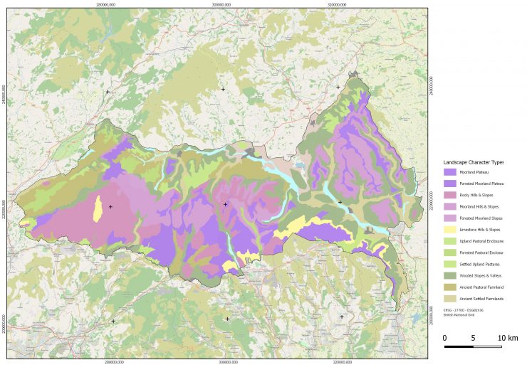
Geoffrey Griffiths retired from the Department of Geography & Environmental Science at the University of Reading in 2018, after 25 years of teaching and research in GIS (Geographic Information Systems) and landscape ecology. He continues to work on projects in Africa and the UK as a Visiting Professor in the School of Agriculture at the University of Reading and for Landscape Matters. Recent projects for example, have included Sentinel (Trade-offs in Society and Environment in African Agriculture) with the International Institute for Environment and Development (IIED), land use planning in NW Liberia and range management for conservation in Western Kazakhstan with RSPB, funded by SNAPP and the Endangered Landscapes Programme. In the UK he is currently working for the Brecon Beacons National Park Authority (Awdurdod Parc Cenedlaethol Bannau Brycheiniog) on techniques to develop a landscpe strategy for nature recovery across the park.
He is a Fellow of the Royal Geographical Society.
Services:
Landscape Matters has considerable experience in the development and application of Landscape Character Assessment for a range of land use planning and countryside management. We also work overseas, specifically training and capacity building in landscape ecology, land use planning and resource management:
- Definition of Landscape Character Types (LCTs) based on LDU mapping at scales ranging from the regional (1:250,000), through the local (1:50,000) to the farm (land cover parcel) level;
- Analysis of the strength of character and condition of a landscape, providing the tools for:
- evaluating the sensitivity of different landscapes;
- developing landscape strategies and management guidelines for different landscapes.
- Training in landscape character assessment and the use of Geographical Information Systems (GIS) technology. This has involved training both in the UK and overseas, including Cyprus, Malta, Vietnam, Ghana and Liberia, both in landscape mapping and landscape ecology.